We are in the remote archipelago that includes Cape Horn National Park. Discovered in 1616 by a Dutch maritime expedition, Cape Horn is a sheer 1,394 foot high rocky promontory overlooking the turbulent Drake Passage.
It's often called the "end of the world" since the weather is often very stormy and the waves are so high that ships seemed to be approaching the edge of the earth.
The captain has declared the weather and sea conditions are favorable, so we prepare to board the zodiacs. Nelson, our Trip Leader, has managed to get our group on the first 2 zodiacs....that will enable us to climb the steps and head to the albatross memorial before it becomes crowded.
There are crew members in wet suits in the water to assist us as we disembark the zodiac.
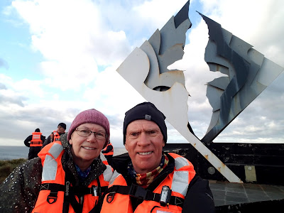
We climb 300+ steps and hurry along the long boardwalk to the Albatross Memorial. We keep our lifejackets on simply because it is windy and there is no way to secure them from blowing away.
And we made it....
One by one or (two x two) we have our photos taken next to the memorial
The memorial is dedicated to the thousands of mariners who lost their lives in the waters around Cape Horn and the Southern Ocean.
In the 19th and early 20th centuries, clipper ships sailed around Cape Horn on their voyages between Europe and Asia. The frequent high winds and storms in the region caused many sailing ships to crash on the rocky islands, and thousands died in their attempt to get past Cape Horn.
The Cape Horn Memorial features an albatross in flight. It is 22 feet high and constructed of steel plates. Because of the strong winds and stormy weather that frequents Cape Horn, the memorial was designed to withstand winds of almost 200 mph.
The Cape Horn area has two lighthouses. The one in the photos is at the Chilean naval station and is the largest and is accessible to visitors. The second smaller one is only about 13 feet high and is located on the actual Cape Horn (where the Atlantic and Pacific Oceans meet) about a mile away.
The tiny Chapel of Stella-Maris is next to the lighthouse, The one-room chapel is only about 12 feet long.
Some views from Cape Horn.
Our ship anchored off shore.
Soon it was time to return to the zodiacs and the ship and we head toward Wulaia Bay.
Originally the site was one of the region's largest Yamana aboriginal settlements and it was described by Charles Darwin and sketched by FitzRoy during their voyages on the HMS Beagle.
We set off on a hike (again we had the choice of 3 hikes of increasing difficulty) that ascend the heavily wooden mountain behind the bay.
Once we made it to the top, we had wonderful views of the Murray Channel, Jemmy Button Island and snow-covered mountain peaks. The hike was quite a strenuous steep climb to an elevation of 700 feet above sea level, but well worth it.
Back down to the shore, we entered the old radio station and the Barrel Post Office.
In years before email, the internet or even a reliable international postal service, sailors used to rely on the kindness of their colleagues to relay messages home. On a long outward journey mariners would leave a letter ashore in pre-designated spots and homeward bound sailors would pick them up and bring them home for onward forwarding by conventional mail.
We picked out a postcard and mailed it to someone in Nebraska once we arrived home.
Then it was time to set sail for Ushuaia, Argentina....nicknamed the city at "The End of the World". It is here where we disembark the ship and continue our journey.
To continue reading, scroll up towards the top of this page and click in the right-hand column the entry entitled: Ushuaia, Argentina: "The City at the End of the World"


No comments:
Post a Comment