Thursday, February 28, 2013

Valporasio, Chile


“A bay bordered by steep hills, stately old Victorian homes, cable cars - no, it's not San Francisco, California. Welcome to Valparaiso.” Founded in 1536, and named after the birthplace of conquistador Diego de Almagro, Valparaiso is Chile's oldest city. It is also the gateway to Chile's central valley and the capital of Santiago, which is about a 1.5 hour drive inland.   

Our day included a city tour of Vina del Mar, the playground city for vacationers, and Valpariso, where the ship docked, and which is a relatively poor working man’s city and then a trip to the Casablanca Valley, which is the heart of Chile’s renowned fine wine district.


Our tour started at 8:00 am when we met up with our guide for the day, Christian “The Van Man”.  The weather forecast was 78 degrees and sunny.  It was not…yet.  We had typical Valparaiso weather which meant fog in the morning and then sunny skies for the afternoon.  Our tour headed toward Vina del Mar, the beach and resort town next to Valparaiso. The water is really too cold here for swimming as the current comes from Antarctica.

First stop was at the Floral Clock.  Christian said there are only 5 of these clocks in the world.  Didn’t know that!  I think this was the 3rd floral clock we have seen on vacations.  Two to go to see them all!  The city is full of parks along the waterfront and is very clean.  When we stopped to take a photo of the castle, Cerro Castillo, the site of the summer residence of Chile’s President, we found these horses having breakfast before they started pulling their carriages.


We stopped by the outside of the town’s museum for a look at the Easter Island statue of a moai.  It was brought over here in 1951. 


Next we traveled to the Casablanca Valley to visit a couple wineries and do a little wine tasting. It was only about 10 am but we’re sure it was 5 o’clock somewhere!  The wines were excellent!


Lunch was at a little restaurant where we could only guess what we were ordering from the menu.  We ended up with a chicken sandwich and a beef “special” that included 2 fried eggs on top of shredded beef.  It was all good and the wait staff had big smiles for us.


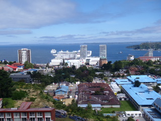
With the skies clear and sunny now, we headed back to Valparaiso for a look at that city before getting back on the ship.  We stopped at an overlook to the city.  It would have been fun to take the funicular (a car on rails to access the city at the top of the hills) but it was too crowded and we didn’t have time.  So our van drove us up for a view.  As with the other cities we have visited, there is a lot of graffiti on the buildings.  But here many of them have murals and are considered graffiti “art”.


It was a very good day; we enjoyed this port.  Next port is Coquimbo, Chile.


Monday, February 25, 2013

Puerto Montt, Chile


Puerto Montt is a city of over 185,000 people and is noteworthy as the capital of Chile's tenth region which includes the well-known Lake District. Its ports serves as the shipping point for many of its locally produced products, mainly lumber and its by-products as well as an abundance of farm-raised salmon.

 The forecast for today was 75 degrees and sunny.  But after tendering in to the dock from the ship, all we saw were clouds, hanging low in the sky and it felt like it could rain.  The picturesque volcano, Mt. Osorno was nowhere to be seen.
But, our group of 20 found our guide and bus driver and off we went, hoping conditions would improve.
Our first stop was a visit to the town of Puerto Varas, on the country’s largest lake, Lago Llanquihue (pronounced yahn-KEY-way) and known as the City of Roses.

Its origins are German since immigrants from Germany were encouraged by the Chilean government to settle and develop this potentially rich part of Chile, which until then had been overlooked.  This was a pit stop in one of the seasons of the Amazing Race.  Our guide thought it was the year the cowboys won.  Their task in this town was to gather ingredients for a local delicacy.  We’ll have to try and find that episode on the internet and watch it again.

 By this time, the clouds are burning off and we could see blue sky and glimpses of the volcano in the distance.  We visited the Vicente Perez Rosales National Park and the Petrohue Falls and Rapids, which provided us with fantastic views of both the volcano and the falls.

 After traveling several miles over the Pan-American Highway, we entered the rich agricultural part of the region where there are many farms and ranches, with several varieties of livestock, including llamas and emus. Our itinerary included a stop at the bavarian-styled village of Frutillar, with the near-conical, snow-capped volcano, Mt. Osorno, in the background.


We visited Lago Todos, also known as Emerald Lake. The road to this area is unpaved and traverses a lava field before heading back toward Puerto Montt.


We are coffee drinkers and found the following interesting as we had quite the adventure in Australia back in 2010 when we wanted a cup of coffee and had to quickly learn the difference between “long black, short black, flat white”, etc.
“If you ask for coffee (café) in Chile, surprise!—you nearly always will get a cup of plain old hot water and a puzzled stare from the waiter if you seem to expect more.  There will be a can of Nescafe and a sugar jar on the table, and you’re expected to make your own coffee mixture.  If, however, you want brewed coffee (sometimes espresso, sometimes percolated), you must ask for café expresso or café-café. If you ask for café con leche (milk), you’re liable to be served a glass of hot milk, into which you spoon the Nescafe.  Café-café con crema comes as close to coffee with cream as North Americans would drink it.  But that doesn’t always work either.  Getting a cup of coffee in Chile can be fun and something of a mild adventure.”

It was a great day in a beautiful area of Chile.  The tour company, GV Tours, was top-notch and provided us with a wonderful experience.

Sunday, February 24, 2013

A day at sea...


A day at sea and we decide to do something we don’t usually do….attend the Art Auction!  We knew that this would be the day the Navigation Map for this leg of the voyage would be auctioned.  This cruise is actually 3 voyages, back-to-back.  With each voyage there is a navigation map that details the exact route the ship takes.  All the officers sign the map and it is auctioned off, with the proceeds going to a Princess Cruise line charity.


We had heard that the map of the first voyage sold for $1,500.  So we were interested to see what the map of the voyage going ‘round the horn’ would sell for so off we went to the Art Auction.

 
These auctions don’t usually interest us as the art work offered is neither to our liking or in our budget.  But today we settled in at a table and had an interesting chat with a lady who has cruised many, many times.  It was fun to visit with her about her favorite places.

 
Then the auction started and I think only one piece of art sold prior to the bidding for the Navigation Map.  The bidding started out at $450 and ended up being a battle between two people….a man a few tables away and the lady we were sitting with.  Seems she was the one that bought the first voyage map and wanted this one, too.  Back and forth those two went in $50-100 increments until the man finally bowed out and the lady we were sitting with won the auction with her bid of $4,050!!  And she didn’t even blink an eye at that amount!


The man came over to congratulate her and he started talking about his excursion the other day to Antarctica.  He said it was well worth the $3,000 to fly and land on Antarctica!  Gulp!  That’s way more than what I thought the tour sold for.  Anyway, he had wanted to buy the map because he had gone to Antarctica.  WOW!


And it’s Formal Night so here we are.

Scenic cruising to Amalia Glacier


Today’s destination was scenic cruising though Chile’s inlets to the Amalia Glacier.  The Southern Patagonian Ice Field covered the entirety of southern Chile 10,000 years ago and helped form the fjords of southern Chile’s Pacific Coast.  The unspoiled scenery is filled with dramatic rock formations and snowcapped mountain peaks.
Never realized there were so many little islands along the coast of Chile

 
Ready to start the scenic cruising with a White Chocolate Latte

Located in the central part of the Southern Patagonian Ice Fields, the Amalia Glacier descends from the Andes Mountains and sits towering above the sea. Because of the glacier's immense weight, the oxygen has been pressed out of the ice, giving it an amazingly beautiful crystalline appearance.

 
The Amalia Glacier is one of three spectacular glaciers that are truly one-in-a-lifetime sights to behold. Approximately 73 square miles in area, the Amalia's mammoth blue mountain of ice is constantly changing, and like other glaciers, gradually shrinking.

 
From start to finish, it was a spectacular show of beauty today as we cruised through the inlets.  Pictures don’t do it justice, but here they are:

Amalia Glacier
Proof we are really here!

Ice "bergy bites"

A fishing boat with little boats following in tow


A rainbow to end the day
 
Sunset in the fjords

 
After a day of sail on the Pacific coast, we will reach our next port, Puerto Montt, Chile. 

Saturday, February 23, 2013

Punta Arenas, Chile


Punta Arenas is considered the largest southernmost city on the South American mainland and is located in one of the wildest, remote regions of the earth.


The city was the principal coaling and supply station for ships rounding the Horn, as well as a major world supplier of wool from about 1850 to 1914, when it was one of the busiest ports in the world.  That ended when the Panama Canal opened in 1914 and ships no longer needed to round Cape Horn.  The situation grew worse as wool from New Zealand and Australia began to compete with Punta Arenas’ major product.


Our tour for the day included a trip outside the city to a fort and then a penquin colony.  We were fortunate that the weather today was quite pleasant, temps in the 50’s and no wind.  This area is known for very harsh weather conditions.  Winter lasts from April to December.  The month of February is ‘summer’. 


As we headed toward Fort Bulnes, we stopped at a marker that identifies the geographic center of Chile.  What??  I thought we were near the bottom of Chile, which is a long and narrow country on the west side of South America.  Then we learned that Chile claims a pie-shaped portion of Antarctica, so therefore, this marks the halfway point between Arica at the top of Chile and the South Pole.


Fort Bulnes was built in 1843 when the Chilean government began to realize that if they did not colonize the extreme south, they might lose it to the neighboring Argentines or to the British, who had just colonized the Falkland Islands right under the nose of the Argentines.  So a group of 21 soldiers and their families established the fort.  The location proved so inhospitable, however, that five years later it was abandoned and a new outpost was created further north at a site that eventually became the city of Punta Arenas.  The fort is now a national historic site and has been faithfully reconstructed using the same materials used in the original buildings (sod and wood).  The original fort was burned by a nasty pirate in the 1800’s.

 
Strange looking tree.  Nasty thorns!

Our guide explaining these trees

Everything in the fort was made of wood.

The entrance to the tunnels where the settlers would hide during pirate attacks.

The fort was quite interesting and it was easy to imagine how difficult life must have been like for the 33 men, women, and children trying to survive at the fort.


Our next trek was 35 miles in the opposite direction from Punta Arenas to a small penquin colony on Otway Sound.  Driving there we passed a coal mining area.  The spoils reminded of us of Colstrip.

The coal mining spoils.
 

After walking almost a half mile to the viewing area, we saw only about 24 penquins and had to stand behind a structure like a hunting blind.  It was disappointing, especially to those in our group who had not gone to Punta Tomba with us, where there were thousands of penquins and we could walk amongst them.  I guess somebody forgot to tell the penquins to come in early from their ocean feeding so the tourists could take photos! LOL
About 2 dozen penquins on the beach

There were far more penquins in the gift shop!


It was a long day of siteseeing but we enjoyed it all (well, maybe not so much the many miles in a bus on gravel roads).  A nice area to visit, but with the harsh weather conditions we wouldn’t want to live here!
A replica of Magellan's ship, for which the strait is named.  We only saw it from the bus.


Next day is scenic cruising through the Chilean fjords.