Monday, May 28, 2018

Acclimatization is complete and off we go higher and higher

It's May 2 and we are headed to Tengbouche.  Today's trek is about 6 hours and we walk the well-worn Everest trail high above the Dudh Kosi river.  As we follow the path, we get our first really good views of the great peaks of the Khumbu range:  Everest, Lhotse, Nuptse and Ama Dablam.

That's Everest in the upper left corner background.


We pass by several villages and numerous tea houses.

We cross the Dudh Kosi River again
passing by beautiful rhododendron trees

and make a steep climb to Tengbouche, home of an impressive and recently rebuilt monastery. 


Tengbouche is where we spend the night at 12,795 ft..

 The accommodations are now getting a little rough.  We have no showers or toilets in the rooms.
Dining hall

The next morning we start our trek to Dingbouche, about 5 hours of trekking. The trail crosses an airy suspension bridge...you can see a yak crossing it in the upper left corner of the photo below.
 We walk toward Pangboche, the home for the Sherpas who work on the mountain each post-monsoon season.

We have excellent views on this beautiful morning of Ama Dablam (Mother's Charm Box).


We continue our hike along the valley and...
 recross the river.

...bringing us to the farming village of Dingboche at 14,465 feet above sea level. which is the highest I have ever trekked.

 We stay 2 nights in Dingboche, again going on hikes up to 16,076 ft to acclimatize and enjoy the views.  We are preparing our bodies for the low levels of oxygen.


And then we reach the point that I have been looking forward to...
First Pasang shows us how to take the perfect photo...

Then I try it....

Oh, yeah!!

And our team all take their turns for photos at this most awesome point.

Our group photo

This day will be burned in my memory forever!

The next day is May 5, and we are getting ever so much closer to Everest Base Camp.  Today we trek toward Lobuche.


Ahead of us is the trekking peak of Lobuje East (20,075 ft) and to our left is the north face of Taweche, where many ascents took place in the 1980s and 1990s.

 I thought the stone houses we passed were very picturesque against the gigantic mountains.

After three hours we reach the small collection of lodges at Thukla (15,153 ft), where we have lunch.

We cross the river, this time over stones.


We then continue the walk up to the Everest memorials.
Dedicated to people who lost their life while attempting to summit Everest.


We have a great views of Ama Dablam, Cholatse and Taweche mountains.

From Thukla the trail starts to climb steeply up beside the glacier moraine and we arrive in Loboche, where we spend the night in the tea houses at 16,207 ft.

We are up early the next day (May 6) to start our trek to Gorak Shep.

 It is a steep climb to 17, 126 ft.

Gorak Shep is the site of the 1953 Everest Expedition's base camp.
After lunch and a little rest, we set out to climb to the summit of Kala Pattar (18,514 ft) in time to watch the sunset.  The climb takes at least 3 hours.

Along the way we have great views of Everest and the Khumbu Icefall..
 as well as Lhotse, Nuptse, and Pumori.

But, as is typical in the mountains, the clouds move in and cover the view in the afternoon.


 Soon, we could hardly see anything...
 ...but we still enjoyed every minute at 18,514 ft.

We headed back to Gorak Shep to spend the night, and along the way we saw our first glimpse of Everest Base Camp and the Khumba Icefield way in the distance.

Tomorrow we reach our goal...Everest Base Camp!

To continue, scroll down and click on "Newer Post".

The trek to Everest Base Camp begins.

It's Saturday, April 28.  We were up and off to the airport early with a bag breakfast to eat along the way.
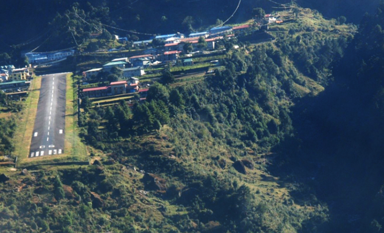
We fly to the village of Lukla, just a 30-40 minute flight in a small 16-passenger plane over the mountains.  It is considered to be "the world's most dangerous airport" with a short runway of 1,729 feet, nestled between mountains.

One end of the runway is the side of a mountain; at the other end is a 2,000 foot drop off the cliff. There is no room for error or second chances on landing.  My assigned seat is #13!

 With a sigh of relief, we safely land in Lukla.
We meet the rest of the trek staff and porters and set off to start our trek.

This is the gateway to the Everest Base Camp Trail.  Finally my adventure really begins.
We trek to the village of Phakding, situated on the bank of the Dudh Kosi river, where we stay overnight at the Royal Sherpa Resort...
...we have accommodations for our team of 9 trekkers plus 3 guides and also our team of yaks, which carry our supplies and duffels.
The next morning we start out early for a 7-8 hour trek before reaching Namche Bazaar.  
We follow the banks of the Dudh Kosi, crossing it twice by small suspension bridges and enter the Sagarmatha National Park.


We climb steeply for about two hours up Namche Hill to reach Namche Bazaar at 11,155 ft.


This is a prosperous trading town and the capital of the Khumbu Region.  Many Tibetans cross the nearby border to trade their goods here so there is a large local market.  We spend 3 nights here in Namche to acclimatize to the low oxygen levels.

Here I am with  our team leaders. 

During the days in Namche we rest and do some trekking to higher altitudes.  On the first morning we hike up to the Sherpa Museum at 11, 811 ft.
Pasang explains to us the prayer wheel.
On this monument are two rocks:  the one on the left is from the summit of Mount Everest; the one on the right is from the Dead Sea....rocks from the highest point on earth and the lowest.

This statue is of Sir Edmund Hillary.  The 1953 British Mount Everest expedition was the ninth mountaineering expedition to attempt the first ascent of Mount Everest, and the first confirmed to have succeeded when Edmund Hillary and Tenzing Norgay reached the summit in May, 1953.

High above Namche we can see there are mountains out there but the clouds mostly obscure them.


Back down in Namche we visit with the last living team member from the 1953 Everest Expedition, Kancha Sherpa.  Back in 1953, he was in his 20's.  He wasn't much of a talker, but did like having his photograph taken with our team.

The next morning we have a much better view of the mountains and Namche.

We hike up to Shangbouche Hill for views of the whole Everest region.


 We're back in Namche for one more night.

The next morning we start our trek again toward Everest Base Camp.

To continue reading, scroll down and click on "Newer Post".